In various fields such as aviation, topography, and geodesy, the choice of altitude measurement system holds significant importance. This article aims to compare and contrast two widely used systems: Above Ground Level (AGL) and Mean Sea Level (MSL).
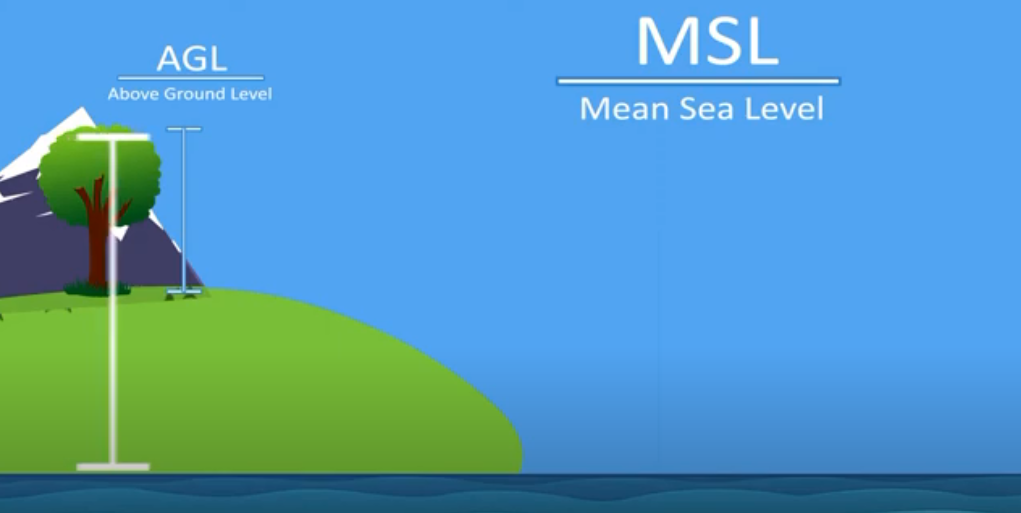
AGL refers to the height of an object or point relative to the local ground or surface, while MSL represents the average height of the ocean surface. We will delve into their definitions, applications, advantages, and limitations to gain a comprehensive understanding.
Above Ground Level (AGL)
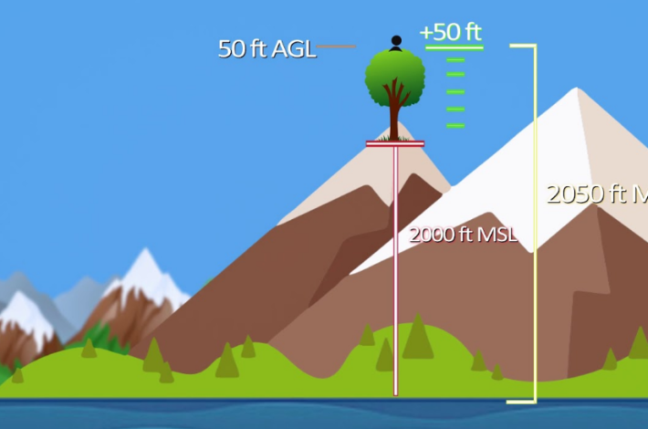
AGL, also known as height above ground, measures the vertical distance between an aircraft, object, or point and the supporting surface. It is predominantly used in aviation to ensure safe altitudes during takeoff, landing, and flight.
Height above sea level can be determined using radar altimeters, barometric altimeters, or other specialized instruments.
Applications of AGL:
- Aviation: AGL plays a critical role in maintaining a safe altitude during takeoff, landing, and flight, particularly for low-level flights, approach procedures, and obstacle avoidance;
- Construction and Engineering: The construction industry relies on AGL for site planning, crane operations, and compliance with building height regulations;
- Power Transmission and Telecommunication Infrastructure: AGL measurements are essential for the installation and maintenance of power lines and telecommunication infrastructure, considering height requirements and obstacles;
- Environmental Monitoring: AGL plays a vital role in environmental monitoring, such as measuring vegetation height, tree canopy, or water levels in rivers and lakes;
- Unmanned Aerial Vehicles (UAVs): AGL ensures safe and unobstructed operations of UAVs, especially for aerial photography, inspections, and mapping;
- Advantages of AGL:
One of the key advantages of AGL is its direct correlation with the local terrain and surrounding obstacles. By relating altitude to the terrain, AGL provides precise information for pilots and operators navigating close to the surface. Additionally, AGL allows accurate measurements in areas where precise mean sea level (MSL) data may be unavailable or unreliable.
Applicability in construction and engineering allows for precise measurements and consideration of ground structures and objects during construction projects.
Limitations of AGL:
- AGL is not a universally applicable altitude measurement system as it relies on specific terrain or surface characteristics. This means that the same AGL value can correspond to different altitudes in different locations.
Furthermore, factors such as changes in terrain elevation, variations in height above sea level, and local weather conditions can affect AGL measurements. These limitations make it less suitable for long-range navigation or situations requiring precise vertical positioning.
Mean Sea Level (MSL)
MSL is the average height of the ocean surface, serving as a reference point for altitude measurements. It provides a consistent and standardized vertical reference across different locations.

Applications of Mean Sea Level:
- Aviation: MSL altitude is used for flight planning, air traffic control, and maintaining vertical separation between aircraft;
- Marine Navigation: Mean Sea Level ensures safe passage for ships, considering clearance heights under bridges and navigation in harbors;
- Geodetic Surveys: MSL provides a reference for geodetic measurements and mapping, facilitating accurate positioning and surveying;
- Climate Studies: Mean Sea Level data is crucial for monitoring and studying sea level rise, ocean circulation, and climate change.
Advantages of MSL:
- MSL offers a globally consistent reference point for altitude measurements, making it suitable for long-range navigation, aviation, and marine activities. It provides accurate vertical positioning and facilitates uniformity in data interpretation across different regions.
Limitations of MSL:
- While it provides a standardized reference, it does not account for local variations in terrain or obstacles. Factors such as coastal topography, tidal fluctuations, and storm surges can impact the accuracy of MSL measurements in specific areas.
Additionally, in situations where precise height above the ground or structures is required, MSL may not provide the necessary level of detail.
Mean Sea Level (MSL)
MSL refers to the average height of the ocean surface over a specific period, typically based on long-term observations of tides. It serves as a global benchmark for altitude measurements, providing consistency and stability to the reference plane, and is determined using geodetic methods and satellite measurements.
Applications
MSL is widely used in various fields, including aviation, geodesy, and cartography. In aviation, it’s utilized for flight planning, airspace design, and vertical separation of aircraft. In geodesy and cartography, MSL serves as a reference in map-making, topographic surveys, and height systems.
Applications of Mean Sea Level (MSL):
- Aviation: MSL is used in aviation for flight planning, airspace design, and vertical separation of aircraft, ensuring consistent altitude references across different regions;
- Geodesy and Cartography: MSL serves as a benchmark for geodetic surveys, cartography, and topographic mapping, providing accurate height measurements and establishing height systems;
- Coastal Construction: It’s essential for coastal engineering projects, such as determining seawall parameters, flood protection systems, and evaluating shoreline erosion;
- Climate Change Research: MSL measurements help monitor long-term sea-level changes, contributing to climate change research and assessing its impact on coastal regions;
- Marine Navigation: It serves as a baseline for marine navigation, aiding ships and vessels in determining their vertical position relative to the sea level, crucial for safe navigation and avoiding underwater hazards.
These applications highlight the significance of AGL and MSL in various domains, emphasizing their roles in ensuring safety, accuracy, and consistency in altitude measurements.
Advantages
One of the key advantages of MSL is its global consistency. Regardless of the location, MSL provides a reliable altitude measurement system, enabling consistent and accurate comparisons across different regions. Additionally, MSL allows for easy integration of data from various sources, such as satellite imagery and global positioning systems (GPS).
Advantages of Mean Sea Level (MSL):
- Global Consistency: MSL represents a globally consistent height reference. Regardless of the location, it ensures a reliable and standardized baseline for altitude measurements. Such global consistency enables precise comparisons across different regions and facilitates data integration from various sources;
- Compatibility with Geodetic Systems: It aligns with geodetic models and coordinates, making it compatible with cartographic, geodetic, and surveying applications. It enables the creation of accurate height systems, ensuring measurement consistency across different geodetic networks;
- Long-Range Navigation: It’s particularly advantageous for long-range navigation applications, such as long-distance aviation or marine navigation. It provides a stable reference plane for vertical positioning, contributing to precise and reliable navigation over extensive geographical areas;
- Climate Change Research: MSL measurements play a crucial role in monitoring sea-level changes and assessing the consequences of climate change. By providing a constant baseline, it aids in analyzing long-term trends and understanding the impact of rising sea levels on coastal regions.
These advantages highlight the merits and suitability of AGL and MSL in different scenarios. AGL allows for precise information relevant to local conditions, while MSL offers global consistency and compatibility with geodetic systems, making it particularly valuable for broader applications and long-range navigation.
Limitations
MSL calculations involve complex geodetic models and may require specialized equipment and expertise. Obtaining accurate MSL measurements can be challenging in areas with limited tidal data or significant local sea level variations.
Additionally, MSL does not account for local variations in the ground or surface, making it less suitable for applications requiring precise information about objects close to the ground.
Limitations of Mean Sea Level (MSL):
- Data Availability and Reliability: Obtaining accurate MSL measurements relies on long-term tidal data and complex geodetic models. In some areas, limited tidal data or significant local sea level fluctuations may pose challenges in obtaining precise measurements, potentially affecting the reliability of height references based on MSL;
- Lack of Ground/Surface Information: MSL does not consider local variations in the ground or surface. While it provides a consistent reference plane for altitude measurements, it may not provide detailed information about objects or obstacles close to the ground, limiting its suitability for applications requiring precise alignment with ground level;
- Complexity and Equipment Requirements: Calculating MSL involves complex geodetic models and may require specialized equipment and expertise. Establishing and maintaining accurate measurements can be resource-intensive, making it less accessible in certain regions or industries with limited resources.
Considering these limitations is crucial when choosing between AGL and MSL, as they impact the accuracy, applicability, and reliability of altitude measurements in specific conditions. Understanding these limitations allows for informed decisions regarding the most suitable altitude measurement system for a given task.
Factors Influencing the Choice
The choice between Above Ground Level and Mean Sea Level as a suitable height reference system is influenced by several factors. Here are some key factors to consider:
- Application Area: The specific industry or field where height measurements are required plays a crucial role in choosing between AGL and MSL. For example, in aviation and low-level operations, AGL is often used because it has a direct relation to ground obstacles. On the other hand, in geodesy, cartography, and broader geographic applications, MSL is preferred due to its global consistency and compatibility with geodetic systems;
- Objective of Height Measurements: The purpose for which height measurements are needed also influences the choice. If the goal is precise vertical positioning above the ground or surface, AGL may be more suitable. In contrast, if the objective is to establish consistent height benchmarks across different regions or for long-distance navigation, MSL is the preferred option;
- Available Resources and Technologies: The availability of resources and technologies can affect the choice between AGL and MSL. AGL measurements can be obtained using radar altimeters, barometric altimeters, or specialized instruments. On the other hand, accurate measurements may require complex equipment, access to tidal data, and expertise in geodetic methods;
- Geographic Coverage: The geographic coverage of the area of interest plays a role in the choice of a height reference system. AGL works well for local or regional applications where precise information about ground obstacles is needed. In contrast, MSL provides a consistent reference across large geographic territories, making it suitable for broader or global applications;
- Accuracy and Precision Requirements: The required level of accuracy and precision in height measurements is a critical factor. AGL can provide high-precision measurements near the ground or surface, while MSL ensures a stable reference for consistent comparisons on larger spatial scales. To determine which system can meet the required accuracy standards, specific application requirements must be taken into account;
- Regulatory and Industry Standards: Compliance with regulatory requirements and industry standards can influence the choice of a height reference system. In some industries, such as aviation, there may be specific recommendations or rules prescribing the use of either AGL or MSL based on the nature of the work and safety considerations.
It is important to carefully analyze these factors and assess the specific needs of the application to determine the most suitable height reference system, whether it is AGL or MSL. Each factor plays a role in ensuring accurate and reliable height measurements according to the intended purpose.
Recommendations
Based on the analysis of Above Ground Level and Mean Sea Level systems, here are some recommendations for choosing the appropriate height reference system:
- Consider Application Specifics: Evaluate the specific requirements of the system. If you are involved in local or regional operations that require accurate information about ground obstacles, AGL is recommended. For broader geographic coverage, long-distance navigation, or applications that require global consistency, MSL is preferable;
- Assess Vertical Positioning Needs: Determine the level of precision in vertical positioning required for your specific task. If precise height above a reference plane is important, such as in geodetic surveys or satellite positioning systems, MSL may be more suitable. However, if maintaining a safe height above ground obstacles is a priority, AGL is preferred;
- Evaluate Data Availability: Consider the availability and reliability of the data required for accurate measurements. AGL may have an advantage in areas where precise MSL data may be limited or unreliable. If complete tidal data and complex geodetic models are available, MSL becomes a viable option;
- Analyze Resources and Technologies: Assess the available resources, equipment, and technological capabilities. Height measurements above sea level can be obtained using radar altimeters, barometric altimeters, or specialized instruments. Calculating MSL may require modern equipment, access to tidal data, and experience with geodetic methods;
- Compliance with Standards and Regulations: Take into account industry standards and rules. In some industries, such as aviation, there may be regulations prescribing the use of either AGL or MSL based on safety and operational requirements. Ensure compliance with applicable industry standards;
- Seek Expert Advice: Consult experts in the relevant field, such as geodesy, aviation, or cartography, to gain insights into best practices and industry recommendations regarding height reference systems. Expert consultations can provide valuable recommendations that take into account the specific requirements of your application.
Ultimately, the choice between AGL and MSL should align with the specific needs of your application, considering factors such as accuracy requirements, geographic coverage, available resources, and industry norms. Understanding the strengths and limitations of each system will help make an informed decision and ensure accurate and reliable height measurements.
Conclusions
AGL and MSL are two different height reference systems, each with its advantages and limitations. While AGL provides accurate information near the ground or surface, MSL ensures global consistency and compatibility with geodetic systems.
The choice between AGL and MSL depends on factors such as the application area, measurement objectives, and available resources. Understanding the characteristics of these systems and selecting the appropriate height reference system will enable accurate and reliable height measurements in various domains.